Thursday, 12 November 2009

A walk beside Loweswater

Loweswater turns to the north-west and is the smallest of three lovely lakes often grouped together, the others being Buttermere and Crummock Water. The first part of the walk takes you above the lake on easy graded paths and tracks, with magnificent views for much of the way. The return route leads you beside the charming lake through pleasing deciduous woodland and makes a short detour to see a series of delectable falls, known as Holme Force.

High Nook Farm, built in the sixteenth century, is set among Scots pine. It stands near to an old coffin track that crossed above the farm and continued along the lower slopes of Carling Knott. The coffins, carried on horseback, were taken this way for the dead to be buried at St Bees Abbey.
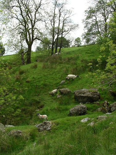
  1. From the small parking area turn left for a couple of steps and then right to cross Dubb’s Beck by Maggie’s Bridge. Stride on across the flat lush pastures of the valley on Maggie Lonnin, with fine views ahead of Carling Knott and Black Crag, the latter a spur of Gavel Fell, which lies behind. To your left looms the large bulk of Mellbreak. Remain on the track as it begins to rise towards High Nook Farm. At 0.5km beyond, at a junction of tracks, take the right branch. At the next Y-junction, a short way along, walk the left branch leading to little High Nook Tarn, a quiet sheet of water lying in a hollow between Carling Knott and Black Crag.
  2. After your visit return to the Y-junction and turn left on an indistinct path. Step across two little streams, negotiate small patches of bog and then follow a grassy swathe that leads down to a footbridge over Highnook Beck, which remains hidden almost to the last step. Beyond, wind a little left and then take, right, the pleasing grassy bridleway that ascends, easily, the southern slopes of Carling Knott to the top corner of Holme Wood. Here the way winds round along the side of the stiled walled plantation of Scots pine with the dour north slopes of Carling Knott now to your left. The bridleway then moves away from the wall and descends to a wide tractor bridge over Holme Beck. Walk on along the continuing track that rises quickly and curves round high on the steep rocky side of Burnbank Fell. Pause here on the open fell, to look over the forest and across the lake for splendid views of Grasmoor and Whiteside.

  3. Carry on for 1.5km along the excellent roller-coaster grassy way, with more fine views across West Cumbria and of Darling Fell on the other side of the Loweswater, the latter glimpsed far below. This delectable high-level way brings you to a ladderstile and a gate. Beyond, pause again as you turn right beside the wall, to see all of Loweswater and the tip of Crummock Water. Follow the track downhill and also where it wends left to pass through another gate. Stroll on, bearing right, to pass twin hillocks on your right. Just where the track bends left and continues to the road, turn right through two gates, onto a pasture and walk ahead beside the wall on the right. Then descend a pleasing grassy path towards Iredale Place, with more good views of Loweswater ahead. Go through two gates and continue ahead, ignoring a track off to the left. Walk the roughly reinforced gated track, with more views of the foot of the lake, to pass right of Jenkinson Place.
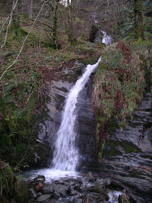
  4. Head on to the next gate to stroll beside a row of hawthorns to your left. Just before Hudson Place, look for a stile, on your left, tucked into the hedge and, beyond, follow the wall of the garden round right to join the access track to the farm. Bear right, signed for Holme Wood, to pass the dwelling and then go left through a gate to walk a walled track heading towards the lake. Dawdle through scattered oaks and look on the lake for pochard, coot and goldeneye. Then go through a gate into glorious deciduous woodland, which at first stretches gently upward and then very steeply to the pines walked above, much earlier. Just before the footbridge over Holme Beck, turn right along an wide track and then ascend a little to stand on another footbridge to see Holme Force plummeting white-topped from high above.

  5. Return to the main track, turn right, cross the footbridge and follow the pleasing way to emerge from the trees by a gate. Stroll the bridleway round, left, to pass Watergate Farm and go on to curve right, with Mellbreak immediately ahead. A short way along, on the left, you reach the car park.
Practicals
  • Start/finish: Small parking area by Maggie’s Bridge, Loweswater, grid ref 135211
  • Map: OS Explorer OL4
  • Distance: 10.5km/6 1/2 miles
  • Time: 3-4 hours
  • Height gain: 170m/560ft
  • Terrain: Good tracks and paths
  • Refreshments: Kirkstyle Inn, Loweswater
For more photos, see "A walk beside Loweswater" on Flickr.

If you enjoyed this blog post, find more walks by Mary Welsh either by clicking through to take a look at A list of walks in the Lake District or use the search bar in the top left hand of your screen.

Please read Mary Welsh's Golden Rules for good, safe walking before setting out.

A walk through Longsleddale

To many walkers this is the most beautiful dale in the Lake District. Through it runs one narrow metalled lane that continues for seven miles to its end at Sadgill. In summer its hedgerows are a glorious array of wild flowers. To one side lie exquisite buttercup meadows that descend delightfully to the River Sprint, which flows quietly here through it tree-shadowed banks on its way to join the Kent. To the east rise steep grassy slopes, seldom walked.

Ahead, as you continue, the craggy top of Kentmere Pike, bulky Harter Fell and Brantstree dramatically fill the skyline, and up through this wild head climbs Gatescarth Pass, a rugged track, the old way to Mardale and Haweswater.

Picturesque farms lie scattered through out the dale and half way along stands St Mary’s Church. It had been closed for refurbishment but now the interior walls have been whitewashed, the woodwork varnished and the grass in the churchyard cut. Much of the work was done by the families that live in the valley, in time for a wedding, an exciting happening in this lovely dale.
Opposite the church stands the community hall, once the valley school. Beside it a large parking area has been provided, two picnic tables and a loo - exceedingly well looked after with a vase of flowers on the window cill.


  1. From the parking area, walk on along the lane for a short way to take a wide left turn. Descend the track to cross the River Sprint and bear right to pass through a gate onto an access track that winds through the meadows and leads to the first dwelling, Hollin Root. Just before the house, climb the slope on the left. Pass through a waymarked gate onto a wide walled ancient track, which winds left. It then rises gently, taking you above Spring Wood, the haunt of that now rare bird, the cuckoo. It is well reinforced all the way to the fell wall and a gate, which gives onto open access moorland beyond. Go ahead on the continuing track, which rises parallel with a wall to your left. Follow the grassy way as it, and the wall, curve right.
  2. Stroll on up over the heather moorland, through a kissing gate and, still keeping beside the wall, look right to see several stone grouse butts. Carry on, to where the grassy trod winds sharp right, with a waymark fifty meters along it. Notice the cotton grass, waving in the breeze reminding you that this is high boggy moorland. Another waymark soon directs you left to go through a gate in the next wall, with a tumbledown wooden sheepfold, beyond and to your left. Keep on the generally dry track as it rises and falls, with glimpses of Skeggles Water behind some rare low craggy outcrops. Cross the tractor bridge over Skeggleswater Dike and on through the waymarked gate. The path then winds and descends to a rather muddy junction of tracks. Pause here to look down over the lush walled pastures towards Staveley, contrasting sharply with the moorland.

  3. After a bit of bog hopping, caused by a stream using the same junction, turn right up a narrow reinforced path to start your return. It is soon joined by a wider track coming in on your left. Go on the steadily rising way and then descend to go through a gate at the opposite end of the wall passed through last. Follow the track as it passes between two solitary straggly hawthorns, set away from the path. Pass an ancient ruin on the left, and walk on until you reach a waymark directing you right down a path. This leads to the edge of shallow Skeggles Water where you might spot duck, black-headed gulls and little grebe. Then return to the waymark and turn right to continue on your way to Longsleddale.
  4. Pass through the next gate and look back for a pleasant overall view of the tarn. Continue on the waymarked path, past a smaller ruin and then, suddenly, the good path gets lost in another boggy area. Cross it where other walkers and cyclists have done, then climb straight up the little slope towards a derelict wall. Wind right to pass through a gate. Beyond, the path generally distinct, occasionally disappears in small boggy patches. After diverting round these wet areas, make sure you look around to pick up the path once more. Soon the slopes beyond Longsleddale come into view and the descending path, at first grassy and clear, disappears for a few steps and then resumes its downward way. It then swings left and traverses the slopes from where you can see the scattered houses of the valley and also Sadgill and its lovely bridge. Pause awhile to view the track climbing steeply up Gatescarth Pass before walking on to pass through the gate in the wall ahead.
  5. Follow the footpath beside the wall on your right and, at the next gate through it, look for the waymarks leading down a steep meadow. There is no path through the lush grass to follow as you descend to the wall at its foot. Here turn right and follow the waymarks, taking you beside a beck to pass to the left of the farmhouse, Till’s Hole. Just before the bridge over the Sprint turn right to walk a track beside it and pass through a signed gate. Keep beside the dancing water, with a steep slope to the right, and follow the path up to a gate, where you join the access track from Tom’s Howe. Go on ahead where there is a choice of ways to continue. Preferably cross the cattle grid and then climb a little right to go through a metal gate to rejoin the continuing track, which soon passes in front of a white house.
  6. Stroll ahead on the lovely way, keeping left of a ruined building and then on a long pasture to go through the next gate. Stay beside the river where, in summer, you might spot a merganser with her brood ‘ski-ing’ along beside her. Follow the wall, pass behind a farmhouse, then climb a little slope with the waymarked fence to your left. Press on to descend to a gate to join a wide track and walk right. Go through two gates at Hollin Root, pass in front of the house to take the left of the next two waymarked gates. Follow the long track, taken near the start of walk, cross the bridge and continue, left, to the road, where you turn right along the lane to the church.

Practicals

  • Start/finish: Large parking area opposite Longsleddale church, grid ref 522029.
  • Map: OS Explorer OL 7.
  • Distance: 12km/7 1/2 miles
  • Time: 4 hours.
  • Height Gain: 250m/815ft
  • Terrain: Good tracks and grassy paths. Several boggy patches. Could be more after heavy rain. Don’t take short cuts over the tussocks or heather. Not to be attempted in the mist. Be alert for cyclists who enjoy this route and whose bikes make no noise on the grass and tracks.
  • Refreshments: Spoilt for choice in Kendal.

For more photos, see "A walk through Longsleddale" on Flickr.

If you enjoyed this blog post, find more walks by Mary Welsh either by clicking through to take a look at A list of walks in the Lake District or use the search bar in the top left hand of your screen.

Please read Mary Welsh's Golden Rules for good, safe walking before setting out.

Friday, 6 November 2009

A walk along the Keswick Railway Track to Castlerigg Stone Circle

The Cockermouth, Keswick and Penrith railway line was last used by trains in 1972. The trackbed crosses and re crosses the lovely meandering River Greta, using bowstring steel bridges – some are upright and some are underslung. In the 1980s the Lake District National Park Authority (LNPA) created the footpath and have maintained it well since then.


Castlerigg Stone Circle stands on a flat area in a large pasture surrounded at a distance by some of the Lake District’s most dramatic fells. The circle is believed to have been put in place during the Stone Age, between BC 2,500 and 1,300. It may have been used as a meeting place for bartering livestock, exchanging partners or celebrating tribal festivals. It may also have been used to calculate the cycle of seasons vital for farmers.


Walk

  1. From the parking area, return to the trackbed and walk on to cross the long bridge over the River Greta, which here flows through a fine gorge. The bridge is an inverted bowstring constructed of steel girders. Thomas Bouch designed them in this way to span the many gorges on the Greta - he also designed the ill-fated Tay Bridge! Go on to pass under a road bridge and then past the historic settlement of Brigham, which lies in a tree-girt hollow. The fast-flowing Greta was ideal for powering the mills established here from the 14th century onwards. Above the hamlet stretches the white-stilted viaduct carrying the A66.
  2. Go on past a sculptured signpost to come to a gate below the modern-day bridge. Another gate gives access to a well graded descending wooden walkway, one of the LDNPs innovations. It passes high over a picturesque stretch of the river. Continue on the pleasing way to go past Low Briery Holiday Village. Read the interesting information board about the history of the area including its bobbin mill, which closed in 1961. Stroll on, crossing more bridges to reach a refurbished hut, on the right, once used by the navvies (navigators), the builders of the track. There is more information here about the railway line, and seats both inside and out.


  3. Cross the next bridge and, at its end, turn right onto a signposted path that ascends through trees to a kissing gate. Beyond, go on to half-way up the field above to a signpost that directs you, right. Pass through another kissing gate and then on through the refurbished underpass below the busy A66. Once through, take the next signed kissing gate and slant up the slope to the road - the old route to Keswick from Penrith. Turn left and then, after0.5km, bear right. A short way along turn right again and walk the quiet way for 1km to the entrance of the stone circle, where you will want to wander around the great stones. They form an oval shape but this circle is unique in having extra stones forming an oblong on one side.
  4. After enjoying this wonderful atmospheric site return to the road and continue on along it for 1.2km (no pavement) to join the A591 coming in on your right, which you cross and walk on for a few steps. Wind on round right for a few more steps, towards the town, and then descend right before the Travis Perkins Works to drop down steps to the railway track once more. Turn right, go under the road bridge and continue to cross the wide high bridge over the River Greta. A short way on along the track beyond brings you back to the parking area.
Practicals
  • Start/finish: The old station yard at Keswick, OS Explorer OL4. If approaching from the south east on the A591 and the A5271, turn acute right just before you reach the main shopping centre, at a major junction signposted for the museum, leisure centre and Keswick Hotel. Follow the road past the museum, and where it winds round the hotel. Continue on round to a mini-roundabout. Turn left and left again, just before the rear of the leisure centre, to make use of the parking bays at the end of the old railway track.
  • Distance: 7.4km/4.1/2 miles
  • Time: 2-3 hours
  • Height gain: 40m/130ft
  • Terrain: The old railway track is level and in good condition. Some quiet road walking.
  • Refreshments: Good choice in Keswick
For more photos, see "A walk along the Keswick Railway Track to Castlerigg Stone Circle" on Flickr.

If you enjoyed this blog post, find more walks by Mary Welsh either by clicking through to take a look at A list of walks in the Lake District or use the search bar in the top left hand of your screen.

Please read Mary Welsh's Golden Rules for good, safe walking before setting out.

A walk to Cold Pike and Pike o'Blisco

Cold Pike and Pike o’ Blisco, two fine fells separated by a broad flat col, lie to the north of the brow of Wrynose Pass. The path to the col, originally made by miners, leads from the north side of Pass, goes by the Red Tarn and then descends into Oxendale and Great Langdale. It is well used by walkers and the surface had become quite rough from the trampling of many boots and from weathering. However some repairs have been made since last winter and many bags of stone have been delivered to the side of the path and more work is being done.

Cold Pike visited first, on grass – sometimes boggy grass, has three rocky summits and it is difficult to tell which is the highest; it is possible to reach all three and then perhaps you can make up your own mind. The OS map seems to suggest that the one to the north is the highest, but when looking at them from below each one, in turn, seems to be higher than the other two.


To reach Pike o’ Blisco, the reinforced path becomes quite red as you descend from Cold Pike. Look for tiny pieces of the iron-ore, haematite, among the red sandstone. Pick up a small piece and feel how heavy it is.


The path up to shapely Pike o’ Blisco leaves from the col and takes you fairly easily to the summit, the rocks giving good purchase to your boots. The descent, seemingly rarely used, is mainly on grass, a delight to come down to the main track, with only a short distance before you reach the Pass.

The walk
  1. From the Three Shire Stone, on Wrynose Pass, take the signed footpath on the same side of the narrow road. Follow it as it winds round a marshy area and then begins to climb. Just before it turns sharp right, look for an easy-to-miss tiny cairn (just a few stones) on your left. This is the indistinct start of the path to Cold Pike. Once away from the main track the path emerges but then it gets lost in a wet area where you will have to find your own way. Beyond, it becomes distinct, taking you half-right over the hillocky fellside, towards the three humps of the Pike.
  2. Step across a small stream and go on until you reach a wider beck, the infant river Duddon, which you also cross. Turn right here, even though the distinct path goes ahead. Pick your way over rough ground with small vestiges of a path, remaining parallel with the beck for short way, until you reach a good path ahead. Turn left and follow it straight up the slopes before it slants half-right. The path weaves between rocks and boulders and brings you beside the first craggy summit, with a prominent cairn on top, which you might wish to climb, just in case it is the highest point. If not remain on the path that winds round the foot of craggy slopes to a flatter grassy open area with a cairned summit to your left. Then carry on, winding round the crags on your right, to the north side. Climb up here using grassy patches between the outcrops to reach a fine cairn. This is probably the highest of the three summits (701m/2259ft). From here across a shatter of rocks you can see another cairn. The view of the Crinkles, with Bowfell peeping over the top, and of Pike o’ Bliscoe, is stunning.
  3. Descend the same way and re-join the path to carry on beside a small beck, to your left. Then drop down to the wide track, used by many walkers climbing up to start their walk along the Crinkles. Turn right and descend to step across the outlet from Red Tarn and carry on along the now red path. Climb the narrower path immediately ahead in the direction of Pike o’ Blisco. The path has been reinforced in the past and leads you distinctly upwards. When in doubt look for rough cairns, and go on. As you near the top the cairns are larger and it is best to follow them, though there are several other small paths, leading upwards. Eventually a grassy path leads you up a gully to the summit plateau.
  4. To reach the splendid colourful summit cairn (705m/2304ft), turn left and walk along the plateau, winding between the rocks and ledges, and then curve round right on easy rocks to reach the cairn, situated on a platform of naked rock. Just below are shelves of rock, out of the north wind, ideal for your lunch break. Return along the plateau towards the second top, not quite so high or so perfect a cairn, which you might wish to ascend. Descend from this by the same route and continue on, a little east, ignoring any paths heading down to Great Langdale or Blea Tarn.
  5. Wind right, west, below the southern face of the Pike, on a clear grassy path. This drops pleasantly down, passing through low ridges of rocks to go on following the path in the direction of Black Crag. As you approach you can see the cairn on the top and may wish to make the short climb to it. If so, return by the same route to pick up the path once more. Stroll on the path as it curves a little east below Black Crag and passes through a small but very wet area, where it gets lost, only to reappear in a few steps. Pause here to look at Black Crag’s Needle, which so impressed Alfred Wainwright. He described it as follows “The smooth and slender pinnacle, detached from the face of Black Crag, is precariously balanced on a massive plinth of rock, 12 ft high, the total height to the tip being 35ft”.


  6. Carry on along the path so that you can by-pass Long Crag, keeping to its eastern end. Then the path slants right, goes on down and becomes fainter and fainter, passing an unusual sheepfold away to your left. Keep on down in the same general direction, past a walled sheepfold to your right, from where you can probably spot the cars on the brow of the Pass. Suddenly you arrive at the main path where you turn left to descend to where you have parked

Practicals
  • Start/finish: The brow of Wrynose Pass, close to the Three Shire Stone, grid ref 276027, where there are several spaces. Just beyond, in the direction of Little Langdale, is a larger hard standing area, on the south side of the road, with enough room for eight to ten cars.
  • Map: OS Explorer OL6, Lakes south-western area.
  • Distance: 9.5km/6miles
  • Time: 4-5 hours.
  • Height gain: 1428ft/345m.
  • Terrain: Grassy paths for most of the way to Cold Pike. Reinforced paths, rough in a few places, from Cold Pike summit to Pike o’ Blisco’s summit. Grassy descent almost to Wrynose Pass parking.
  • Refreshments: Three Shires Inn, Little Langdale. The Newfield, Seathwaite.

View Larger Map

This article appeared originally in Cumbria magazine.

For more photos, see "A walk to Cold Pike and Pike o'Blisco" on Flickr.

If you enjoyed this blog post, find more walks by Mary Welsh either by clicking through to take a look at A list of walks in the Lake District or use the search bar in the top left hand of your screen.

Please read Mary Welsh's Golden Rules for good, safe walking before setting out.

Thursday, 5 November 2009

Profile of Mary Welsh

"Every year hundreds of walkers in the Lake District place themselves in the hands of Mary Welsh. Meet her and it isn't hard to see why," says Cumbria Life magazine. "A sixty-something, she's enthusiastic, imperturbable and, above all, considerate - someone you would happily rely on."

Mary is an award-winning writer of walking books and a travel writer, having produced more than forty walking guide books. She writes regular columns in newspapers (290 walks in the Westmorland Gazette to date), in several magazines including Country Walking (over 385 walks) and for the internet. She has broadcast and appeared on television.

She says “I stood in London’s Oxford Street the other day. A drill was digging up the pavement, the crowds were enormous, the traffic horrendous, I thought ‘What am I doing here? I must be mad. I must return now, to Cumbria, put on my waterproofs and boots and set off into the quiet of the Lakes to where I feel I really belong’ – and I did just that.”

Mary's Walks in the Lake District have been published by the following:

Dalesman

Walks Around Coniston and Hawkshead
Walks Around Ullswater
Teashop Walks in the Lake District

Questa
Easy Rambles Around Wasdale
Easy Rambles Around Dunnerdale
Easy Rambles Around Eskdale
Walks with Children –Malham & Airedale
Walks with Children – Ribblesdale
Walks with children – Wensleydale
Walks with Children – Swaledale
New book to be published in 2010, Easy Rambles Around Ennerdale

Cicerone
Walks to Yorkshire Waterfalls
More Walks to Yorkshire Waterfalls
Lancaster Canal Walks
Walks from the Leeds-Liverpool Canal
Waterfall Walks – Teesdale and the High Pennines
Walking in Lancashire

Sigma
Country Walks around Kendal
Walking the Howgills
North Lakeland Walks with Children
Walking the Lakeland Fringes – The South-West

Countryside
A Country Journal

Westmorland Gazette
A Naturalist’s Guide to Lakeland Waterfalls
A Second Naturalist’s Guide to Lakeland Waterfalls
A Third Naturalist’s guide to Lakeland Waterfalls
A Fourth Naturalist’s Guide to Lakeland Waterfalls
Welsh Walks in Cumbria
Bowness Walks

Clan Walk Guides
Walking The Isle of Arran
Walking The Isle of Skye
Walking Wester Ross
Walking Perthshire
Walking The Western Isles
Walking Orkney
Walking Shetland
Walking The Isles of Islay, Jura and Colonsay
Walking Glenfinnan, The Road to the Isles (Morar, Ardnamurchan, Moidart, Morven, Canna, Rum, Eigg & Muck)
Walking The Isles of Mull (Iona, Coll and Tiree)
Walking Dumfries and Galloway
Walking Argyll and Bute
Walking Deeside, Donside and Angus
Walking The Trossachs, Loch Lomondside and the Campsie Fells
Walking Glencoe, Lochaber and the Great Glen
Walking Strathspey, Moray, Banff and Buchan

Other Clan books in preparation (to be published in 2010)
Loch Ness, Easter Ross and the Black Isle
Caithness and Sutherland

Please read Mary Welsh's Golden Rules for good, safe walking before setting out.

A list of walks in the Lake District

To find your Walk in the Lake District, please click on any of the geographical regions below. Alternatively find your Walk in the Lake District through the search box to the right.

All walks give details as to the route and a list of practicals such as map reference and length of walk.

Please read Mary Welsh's Golden Rules for good, safe walking before setting out.

Walks in the Northern Lake District
Walks in the Western Lake District
Walks in the Eastern Lake District
Walks in the Southern Lake District
Walks in the North Eastern Lake District
Walks in North Western Lake District
Walks in the South Western Lake District
Walks in the South Eastern Lake District